
When surveying a single residential lot, a commercial building pad, or a localized municipal subdivision, treating a portion of the Earth’s surface as a flat plane introduces negligible error. However, as project boundaries expand to span entire states, cross national borders, connect intercontinental telecommunication grids, or build national mapping frameworks, the flat-Earth assumption breaks down completely. Geodetic surveying is the highest-order branch of surveying science. It is dedicated to measuring large areas of the Earth’s surface with extreme, millimeter-level precision while explicitly accounting for the planet’s actual physical shape, rotational flattening, tectonic plate motion, and subtle local variations in the Earth’s gravitational field.
The Mathematical Surfaces of Geodesy
To understand why geodetic surveying is necessary, one must examine the three distinct geometric and physical surfaces used to model our planet:
- The Topographic Surface: The actual physical surface of the Earth, featuring rugged mountain ranges, deep ocean trenches, rolling hills, and river valleys. This irregular surface is far too complex to serve directly as a mathematical reference frame for computations.
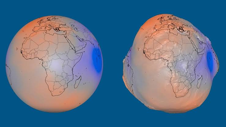
- The Geoid: An equipotential surface of the Earth’s gravity field that best corresponds to global mean sea level, extended continuously beneath the continents. Because the Earth’s interior mass distribution is uneven—dense mountain roots and heavy mineral deposits pull water slightly upward, while deep ocean trenches exert weaker gravitational pull—the geoid is an undulating, potato-shaped surface. Crucially, the direction of the plumb line (gravity) is everywhere perpendicular to the geoid, making it the fundamental physical reference surface for true vertical elevations.
- The Reference Ellipsoid: A mathematically smooth oblate spheroid generated by rotating an ellipse around the Earth’s polar axis, flattened slightly at the poles due to centrifugal force from planetary rotation. Modern global navigation and mapping systems rely on geocentric reference ellipsoids, such as WGS84 (World Geodetic System 1984) and GRS80 (Geodetic Reference System 1980).
Geodetic surveyors bridge these models using a fundamental equation that relates ellipsoidal height ( , measured by GNSS satellites above the smooth mathematical ellipsoid), orthometric height ( , true elevation above the geoid/sea level), and geoid undulation ( , the separation distance between the ellipsoid and the geoid):
Without high-resolution geoid models computed by geodesists, raw satellite elevation readings could differ from true sea-level water flow by up to 100 meters in certain parts of the world—a catastrophic error for gravity-fed canals, interstate water pipelines, and flood control levees.
Geodetic Instrumentation and Space-Age Techniques
Historically, geodetic networks were built through massive continental triangulation chains using heavy optical theodolites, invar baseline measurement tapes, and precise astronomical observations of stars. Today, geodetic surveying harnesses an advanced suite of terrestrial precision instruments and space-based observables:
- Multi-Constellation GNSS: Geodetic-grade dual- and triple-frequency receivers track signals simultaneously from multiple satellite constellations, including GPS (United States), GLONASS (Russia), Galileo (Europe), and BeiDou (China). By logging carrier-phase observations over extended hours or days and applying advanced atmospheric corrections for ionospheric and tropospheric delays, geodesists achieve sub-millimeter baseline precision over hundreds of kilometers.
- Very Long Baseline Interferometry (VLBI): A global network of massive radio telescopes simultaneously observes natural radio signals emitted by distant quasars billions of light-years away. By measuring minuscule differences in arrival times of these signals across intercontinental antennas, scientists determine Earth baselines to within a few millimeters and monitor microscopic changes in the Earth’s rotation speed and axial orientation in space.
- Satellite Laser Ranging (SLR) and Lunar Laser Ranging: Ground stations fire ultra-short laser pulses at artificial satellites equipped with retroreflectors (and mirrors left on the Moon by Apollo missions), measuring round-trip travel times with extreme precision to pinpoint the Earth’s center of mass and track global sea-level changes.
- Absolute and Relative Gravimeters: Superconducting and free-fall ballistic gravimeters measure tiny local variations in gravitational acceleration ( ) down to the microgal level. These measurements refine regional geoid models and detect subsurface magma movement or groundwater depletion.
Spatial Reference Frames and Tectonic Dynamics
Modern geodetic frameworks are dynamic rather than static because the Earth’s crust is constantly in motion. Tectonic plates drift across the globe at rates between 1 and 10 centimeters per year. In regions like the East African Rift Valley or along the Pacific Ring of Fire, crustal strain accumulates continuously and is measurable over just a few years.
International scientific bodies maintain the International Terrestrial Reference Frame (ITRF), which assigns both 3D coordinates and velocity vectors to global tracking stations to account for tectonic drift. National mapping agencies align regional datums—such as NAD83 (and its modern successor NATRF2022) in North America, ETRF in Europe, or national Continuously Operating Reference Station (CORS) networks—directly to the ITRF. When a local surveyor connects an RTK rover to a national CORS network, they are plugging straight into this high-precision global geodetic infrastructure.
Critical Real-World Applications
Although geodetic surveying operates largely behind the scenes, modern civilization depends heavily upon its foundational accuracy:
- Mega-Infrastructure Alignment: Projects like major cross-border tunnels (such as the Channel Tunnel between England and France), long-span suspension bridges, and high-speed rail networks require high-order geodetic control networks to ensure that tunnels bored from opposite sides meet within millimeters and structural towers remain truly plumb despite Earth curvature.
- Map Projections and GIS Integration: Cartographers rely on geodetic parameters to project curved ellipsoidal coordinates onto flat 2D map grids—such as the Universal Transverse Mercator (UTM) system or State Plane Coordinate Systems—while mathematically quantifying and compensating for scale distortion.
- Earthquake Monitoring and Geodynamics: Dense networks of continuous GNSS stations measure millimeter-scale strain accumulation along active faults before earthquakes strike, helping scientists understand seismic hazards and track regional land subsidence or uplift along vulnerable coastlines.
- Autonomous Navigation and Aviation: Precision aircraft instrument landing systems, autonomous maritime shipping vessels, and precision agricultural machinery all rely on consistent, distortion-free geodetic reference frames to navigate safely.
